The novel coronavirus (COVID-19) epidemic does not seem to have an end in sight. Under such circumstances, eventhe most daily activities, such as going to the movies or getting a cup of coffee, can make people feel uncomfortable. The school has also lengthened the online lectures indefifinitely, and lots of Kingosalready seem to miss their ordinary lives. Although a school full of fellow Kingos may be diffificult to see this semester,why not come to school and get a bit of early summer’s sunshine? Did you know that there is a beautiful walking coursewhere you can meet both the history and modernity of Seoul just outside the back gate of the school? The SungkyunTimes (SKT) walked the beautiful path that is so close to the Seoul campus but that not many Kingos are aware of.
Bugaksan Mountain and Bugak
A Brief Introduction
It is quite well known that Seoul sits in a basin that mountains, such as Bukhansan Mountain, Gwanaksan Mountain, and Achasan Mountain, surround. Among these mountains, Bugaksan Mountain, also known as Baekaksan Mountain, is the highest among the mountains that surround inner Seoul. Bugak Skyway is a tourist road and a hiking trail stretching northeast from Changuimun to Jeongneung Arirang pass.
Inter-Korean Conflict: What Made Bugak Skyway
Although the Bugak Skyway is currently a popular tourism and healing spot for countless tourists and Seoulites, an incident due to inter-Korean conflict is the reason the Bugak Skyway was originally built. On January 21st, 1968, armed communist forces attacked Cheongwadae, the Korean presidential office. A total of 31 North Korean agents made their way through Bugaksan Mountain and were not discovered until they finally made their way. In total shock, the government decided to build a road along the ridges of Bugaksan Mountain for defense and tourism; the government thought that an influx of cars along the new road would naturally prevent the North Koreans from intruding into Seoul through Bugaksan Mountain. The construction started a month after the incident and opened in September of the same year.
Tourism Spots Along the Track
Bugak Skyway is a great place itself, but if you have time to spare, going along the Fortress Wall of Seoul and enjoying a bit of Seoul’s history would be a great option. If you are planning to start your walk from the school’s back gate, you have to pass through the fortress anyway. The fortress offers great photo spots, and it is a great hiking track, too.
A Scent of Joseon’s Seoul
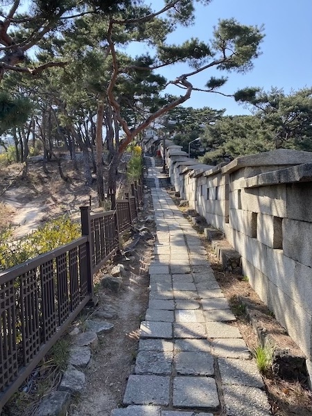
1. Fortress Wall of Seoul
The Fortress Wall of Seoul was built during the Joseon Dynasty to protect the capital from outside invasions. The average height of the fortress is around 5-8m, and the total length of the fortress is about 18.6km. The Fortress Wall of Seoul fully functioned as the wall that protected Seoul from 1396 to 1910, which worked as the longest of its kind. The Fortress Wall is divided into six sections. The Baeak Section is the part of the fortress wall that you will face along the way to the Bugak Skyway.
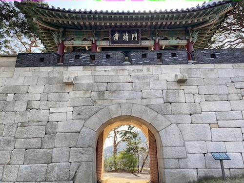
2. Sukjeongmun Gate (From the School Back Gate: 40 Minutes by Foot)
Many Kingos are aware of Dongdaemun and Namdaemun, but not many are aware of Sukjeongmun Gate, the gate that protects the north of Seoul. Sukjeongmun Gate is located along the path of Bugaksan Mountain. The gate was completed in the 5th year of King Taejo (1396), but it moved slightly to the west during the 10th year of Yeonsangun (1504). The gate was not built for people to go through regularly. Rather, it was made to set up the formality of the four gates in the north, south, east, and west of the Seoul Castle and for emergency purposes. A point that hikers should be aware of is that there is a section where you can only enter after getting an access pass from the Malbawi Information Center, due to military reasons. The center allows hikers to enter the section only until 5 p.m.
The Bugak Skyway and the Way Down
After looking around the Fortress Wall of Seoul and Sukjeongmun Gate, head to the Bugak Skyway before dark. The Bugak Palgakjeong Pavilion, the symbol of the Bugak Skyway, will welcome those who have completed the climb.
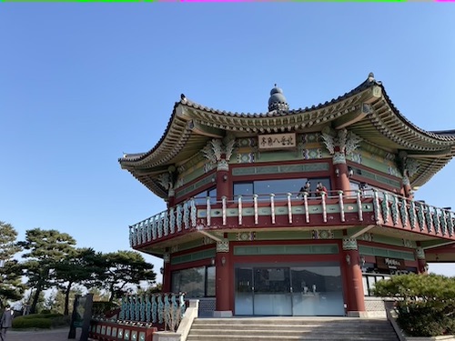
1. Bugak Palgakjeong Pavilion (From Sukjeongmun Gate: 30 Minutes by Foot)
The highlight of the journey would be the night view from the pavilion called Bugak Palgakjeong. The night view of Bugak Palgakjeong is known by many as one of the best night views that Seoul offers. Moreover, around the pavilion, there are cafes and restaurants where hikers and tourists can take a break or have meals. While waiting for the night view, you can write a “slow postcard”, which are postcards that are received a year later after they are sent. It would be a memory to share postcards with family and friends.
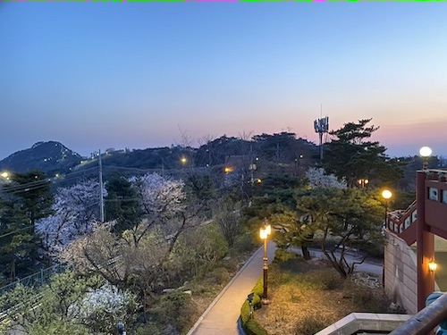
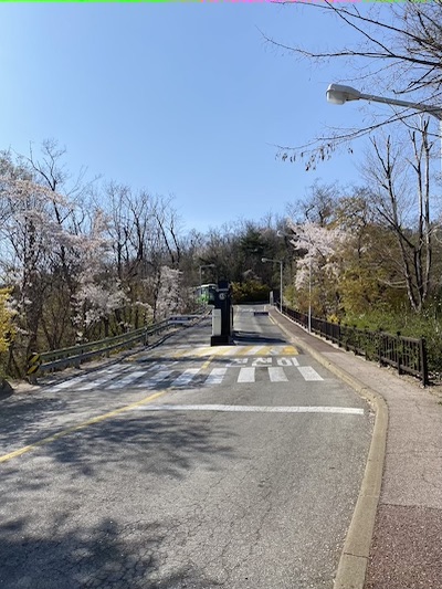
2. The Way Down (From Bugak Palgakjeong Pavilion: 70 Minutes by Foot)
There are mainly two paths to go down the mountain, but the safe way to go down after seeing the night view is to come down towards Jeongneung, where there is a walking path with streetlights. There are also night view spots along the pathway where you can see Seoul’s night view from a different angle. Whenever you feel you are lost, street signs will help your way downhill.
Most Kingos must have been confined to their homes for quite a while. Going out for a walk along the Bugaksan Mountains will definitely be a refresher that will help you get through the epidemic. The Sungkyun Times hopes that this May will be the month to be ordinary and joyful as in any other Mays.